Discover more from The Journal 425
BREAKING - The National Weather Service issued a Winter Storm Watch covering Lake Stevens and much of the 425, with four to eight inches of snow possible beginning Tuesday afternoon through Wednesday.
This is inline with the latest meteorological products available through the EMCWF “European” forecast and the UW Dept. of Atmospheric Science.
See below for access to the most granular and precise forecast available in the 425.
From the National Weather Service:
Western Whatcom County-Western Skagit County-Everett and Vicinity-
East Puget Sound Lowlands-
including Bellingham, Blaine, Point Roberts, Ferndale, Lynden,
Sumas, Sudden Valley, Burlington, Mount Vernon, Sedro-Woolley,
La Conner, Conway, Everett, Lynnwood, Marysville, Stanwood,
Bonney Lake, Maple Valley, Monroe, Woodinville, Arlington,
Granite Falls, Lake Stevens, Snohomish, Gold Bar, Duvall,
Carnation, Fall City, Snoqualmie, North Bend, Covington,
Black Diamond, Orting, and Eatonville
303 PM PST Mon Nov 28 2022
...WINTER STORM WATCH IN EFFECT FROM TUESDAY AFTERNOON THROUGH
WEDNESDAY AFTERNOON...
* WHAT...Heavy snow possible. Total snow accumulations 4 to 8
inches possible.
* WHERE...Lowlands of western Whatcom County, including Point
Roberts, Lummi Island, Bellingham, and Sumas, Lowlands of
western Skagit County, including Cypress Island, Guemes
Island, Anacortes, Mount Vernon, and La Conner, Everett and
vicinity, including Stanwood, Marysville, and Mountlake
Terrace and East Puget Sound Lowlands from Snohomish County to
Pierce County, including Arlington, Gold Bar, Duvall,
Snoqualmie, Buckley, and Eatonville.
* WHEN...From Tuesday afternoon through Wednesday afternoon.
* IMPACTS...Travel could be very difficult.
* ADDITIONAL DETAILS...Higher snow accumulations expected in the
higher hills of the area.
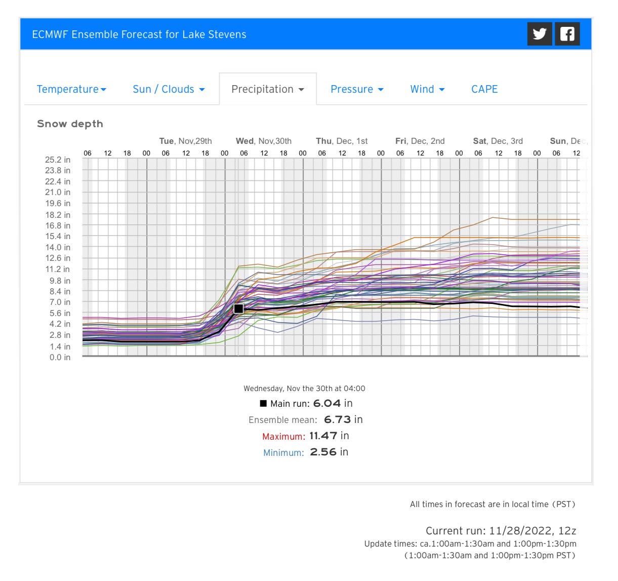
See localized snow forecast models for Lake Stevens below:
J425 was in the process of editing and distributing the latest run of weather models showing snow for the 425 as the National Weather Service update hit. (J425 subscribes to a professional society that provides access to localized forecasting through the world leading “European” model.
During periods of interesting weather we leverage this access for our subscribers. That’s why J425 subscribers were informed of the coming snow storm last Friday).
The latest UW models show most of Snohomish County getting hit with between four to eight inches of snow by midday Wednesday.
Further, J425 ran detailed localized forecasts through the European composite — which takes into account our elevation (461’ at the high school) and relative position closer to the Frasier River outflow (the cold air faucet in Bellingham) to provide the most granular forecast possible for a Lake Stevens resident.
In short, it’ll get cold tonight — but not pipe snapping cold — and then precipitation will begin right around the time the USMNT gets done mopping the floor with Iran — call it noon Tuesday.
Models show an above 90% chance of snow by 4 pm tomorrow. When and if it begins to stick will be a byproduct of how cold it gets tonight and how much (if any ) southerly winds we experience tomorrow.
We’ll leave you with these latest charts and forecasts and update everyone again as necessary.
Because subscriber fees are used to access the European weather service, this is a subscriber only post. Thank you for your support.
Edit — The question has been asked why listen to J425 about weather? Short answer: We’re the only ones with access to Euro modeling running specific forecasts for our coverage area. That said, we do have a track record you can judge us against. 👇
12/20/21
White Christmas for Lake Stevens?
Snow and frigid temperatures are in store for the holiday weekend
12/26/21
Snow & ice paralyze LS streets
Boxing Day snowstorm brings 6”, freezing temps
12/29/21
Officials Caught Unaware by Surprise Holiday Snowstorm (subhead)
Snow 🔜 425 ❄️
Okay, I get it! :) I was reading your original post while having a different mental model in my head about what a Substack should be. You’re thinking of it as news broadcasting, and since weather is a legit topic of local news, you cover it. I think yours is the only Substack that I read that operates on this approach, thus the dissonance with me.
hmm, so many other sources for weather, I wonder why we’d look to you to make the call? I’m prone to trusting the long-term weather bloggers, like Cliff Mass. This is such a weird information landscape we live in these days!