

Discover more from The Journal 425
BOMB CYCLONE APPROACHES
Local forecasters say a record-breaking storm is set to strike the PNW Thursday. How will this low pressure system affect Lake Stevens?
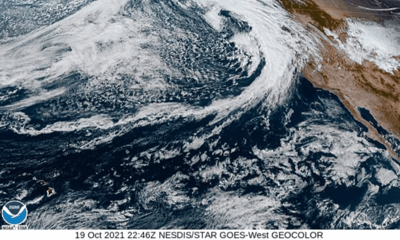
Meteorologists are watching the development of a Pacific “Bomb Cyclone” materializing off the West Coast of the US and forecasted to impact the Pacific Northwest later this week.
“A powerful, unusually deep storm will develop off the Northwest coast Thursday,” predicts veteran Western Washington meteorologist Cliff Mass.
“This storm is deeper than the extreme Columbus Day storm of October 12, 1962--the greatest storm to hit the Northwest in 100 years or more."
- Meteorologist Cliff Mass
The currently developing storm could intensify to a status rivaling the power of Atlantic Hurricanes, say forecasters at AccuWeather. Local forecasters including Mass agree.
“Amazing...the storm, located due west of our coast, has a central pressure is 952 hPa, which is very, very low for a mid-latitude cyclone at our latitude,” Mass continued.
While the bulk of the storm’s energy is headed south, Lake Stevens can expect up to 40 mph wind gusts Wednesday afternoon through Thursday night, accompanied by up to two inches of rain.
The good news for Viking fans is that the bulk of the storm will clear by Friday morning, and aside from a moderate risk of local arterial flooding, the Lake Stevens area will be in the clear by Friday afternoon. The Viking Homecoming game is scheduled for 7 pm Friday at Lake Stevens Stadium.
A bomb cyclone is a rapidly strengthening storm with a central pressure that plummets by 0.71 of an inch of mercury (24 millibars) or more within 24 hours. The process is referred to as bombogenesis. As the pressure drops rapidly in the center of the storm, air rushes in producing damaging winds.
Leftovers from the former Severe Tropical Storm Namtheun will combine with a non-tropical in the Northern Pacific Wednesday before encompassing Western Washington Thursday. Meteorologists predict that the supercharged storm system will surpass the criteria for bombogenesis.
Damaging winds are possible as far north as Vancouver Island, British Columbia, as the storm rapidly intensifies at midweek.
Across Coastal Washington, wind gusts of 40-60 mph are expected with a local max of up to 80 mph as the storm's associated cold front charges eastward.